Nestled in the Southern Atlantic, Bouvet Island is a stark reminder of how geography shapes isolation and environment. Covering just 49 km² and situated roughly 1,600 km from the nearest landmass, this volcanic island is almost entirely glaciated and remains uninhabited to this day. Its remoteness not only challenges human access—it offers a pristine laboratory to study how ecosystems evolve where human influence is minimal and conditions extreme.
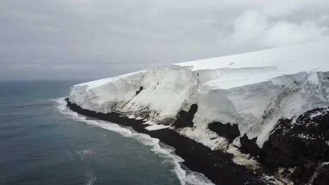
The island’s geological and climatological traits set it apart. A volcanic cone rises to about 780 m, but 93 per cent of the island is covered in ice, and the surrounding seas are harsh and cold. Landing is extremely difficult, meaning the island has never developed infrastructure or significant human presence. From a geography perspective, Bouvet Island illustrates how physical features (volcano, ice cap, oceanic currents) and isolation combine to shape a landform that is nearly untouched—highlighting the twin forces of tectonics and climate in defining remote landscapes.
Studying such extreme geography enriches our understanding in several ways. First, it sharpens our concept of remoteness—how distance from other land, harsh environment, and limited resources converge to produce nearly zero habitation. Second, it underscores how natural reserves on remote islands act as benchmarks for ecological and climatological research with minimal human impact. Finally, Bouvet Island serves as a cautionary example in an era of climate change: while human presence is negligible, the island is still vulnerable to warming seas and melting ice caps. In short, this icy fragment of geology offers big lessons in isolation, environment, and the geography of extremes.